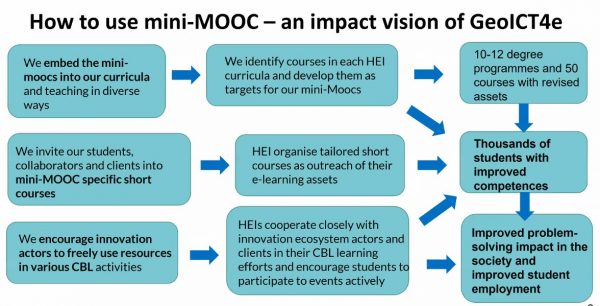
Currently the GeoICT4e experts are designing miniMOOCs related to knowledge and handling of digital geospatial data, sustainable development, climate change, innovations, and entrepreneurship, which are also the themes included in our pedagogical approach,...
Kick-off to Multicompetence Learning and GeoICT4e Ways to Work
A two-days’ event for GeoICT4e experts GeoICT4e project is implemented by eight universities from Finland and Tanzania. Altogether, we comprise a team of 51 experts, who have different knowledge, skills, experience, networks and personalities. Getting to know and...
GeoICT4e project gets started
GeoICT4e -Social innovations in Geo-ICT education at Tanzanian Higher Education Instutions for improved employability project has got funding of 1 923 365 euros from HEI ICI programme for the time period of 4 years, starting from 1 September 2020 and continuing to 31...
Application for GeoICT4e successfully submitted
While the GeoICT project is gradually ending, we have submitted a new HEI-ICI proposal “GeoICT4e” – e referring to employment – for the Ministry for Foreign Affairs. Our new project initiative builds on the success of the previous two HEI ICl-projects between...
Geo-ICT pilot courses running in Tanzania
The Tanzanian partner universities have reviewed and developed several curricula and courses as part of the Geo-ICT project. We aim to collect feedback from the students of each partner university regarding at least one course during 2019, to be able to measure the...
Our News
Our News
Workshop on Multi Competence Learning (MCL) pedagogy
It was a pleasure to welcome 11 experts from the five Tanzania universities to Turku University of Applied Sciences (TUAS) on Tuesday 1st of June 2022. The workshop in TUAS was part of a two-week visit with one aim to explore further the Multi Competence Learning...
Celebrating the Open Access Week 2021
Open Science represents a new approach to the scientific process based on cooperative work and new ways of diffusing knowledge by using digital technologies and new collaborative tools. Open Science is an umbrella term that involves various attempts to remove the...
Training on mobile data collection and QGIS for data visualization and mapping to Sokoine University students
Blog by Ernest Mauya and Msilikale Msilanga The increasing availability of Geospatial technologies and open data is making a global impact on Natural Resources Management and Conservation. With local talents, these can be turned into smart and impactful solutions in...